CAVES OF THE CUETZALAN REGION, Puebla, Mexico.
<<  History Of Exploration Main Index Climate   >>
<<  EPC / PCC 1998 Expedition Reports & Logs CSCA  2000  >>

Cuetzalan 1999 Main Page


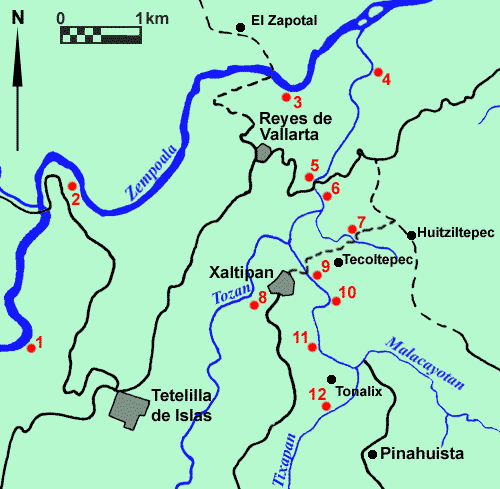
The Lower Tozan, Lower Malacoyatan & Zempoala Rivers

cuet_nth.gif (18814 bytes)
1  /  2  /  3   /  4  /  5  /  6  /  7  /  8  /   9  /  10  /  11   /  12


Site 1

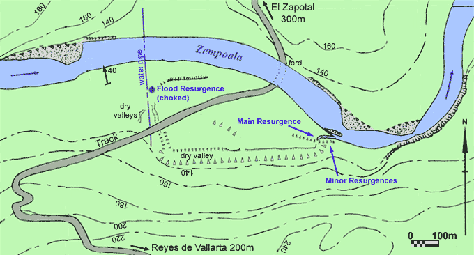
Resurgences at map ref. 504215, 1.6km upstream from bridge on Tetelilla-Huehtla road.
Large resurgence pool directly below rapids.  North side of pool contains a number of washed out joints in cliff on & just above river level.  Pool appears to undercut cliff below water level.
Cave entrance 6m wide by 2m high on east bank and 10m directly above pool leads after 5m to boulder choke with possible route down through boulders at far end of entrance chamber.    Way on appears to be small draughting, crawl in solid rock.
Upstream from resurgence pool are a number of smaller resurgences in boulders at base of cliff.
The whole site is probably responsible for about a quarter of the rivers flow below this point.  Limestone in this area dips about 14 to northwest.  The cliff above the smaller resurgences appears to have been subject to recent collapse.


Site 2

Resurgence on west bank of Zempoala at map ref 512245, 1.3km downstream of bridge on Tetelilla-Huehtla road.
Entrance about 2m square with boulder floor leads after 10m to a sump pool with mud/guano banks.  The sump pool is heavily polluted with waste from bat roost directly above making it a very unattractive (& possibly lethal) dive site.  Resurgence outflow approximately 10 L/s.

70m upriver from resurgence and on same bank is a rock shelter about 2m square formed in deformed limestone.


Site 3

Major resurgence area on south bank of Zempoala at map ref.

nth3.gif (38861 bytes)


Site 4

Cliff at map reference showing discontinuity between limestone and tertiary sediments.

>> Photo


Site 5

Small resurgence cave on west bank of Tozan.  5m to choke.


ite 6

Large area of washed out joints and fractures with limited cave development in cliff on east bank of Tozan.  Many drag folds observed, with axis running east-west.


Site 7

Cave to the south west of the village, approximately 100m above the Tozan valley at map ref. 534219.
Entrance approx 2m high.  Drop down over boulders and silt bank to small immature stream which sinks almost immediately in gravel choke on right.  Upstream follows walking size passage, approx 4m wide, for approximately 40m to where the passage lowers to end at a silt/gravel choke in a flat out crawl after 15m.  Climb up boulders on right just inside entrance leads to small boulder strewn chamber with no continuation.  The roof of the cave is composed of calcerous sandstones & shales of the Pimentia formation.

Another larger cave is reported as being close by but was not located.


Site 8

Large cave entrance, approx. 50m high,  reported by locals as being visible from the Tecoltepec-Huitziltepec road, in the valley that seperates the two villages.    Unexplored.


Site 9

Small cave in cliff formed by water sinking in fields above.

Limestone dips about 12 to west.


Site 10

Resurgence part way up cliff in east bank of Malocayatan on first sharp bend in river approx 400m upstream from bridge.  Outflow of about 1 L/s from two entrances about 1m in diameter.


Site 11

Small resurgence cave at head of steep, loose, gully.


Site 12

Ostonocapan


Top of Page


Cuetzalan 1999 Main Page


<<  EPC / PCC 1998 Expedition Reports & Logs CSCA  2000  >>
<<  History Of Exploration Main Index Climate   >>