| CAVES OF THE CUETZALAN REGION, Puebla, Mexico. | ||||
| << Climate | Main Index | Geology >> | ||
| Expedition Weather Reports | ||||
| WEATHER REPORT: NORTHERN CAVE CLUB
EXPEDITIONS 1991 - 1996 Tim Allen The first expedition in December 1991 began with 10 days continuous low cloud, drizzle and occasional light rain. The weather generally persisted for the rest of the trip although some sunny days were experienced towards the end of the period. The next expedition was moved to April 1993 when better weather was expected. Periods of sun (4-5 days) was mixed with periods of the usual drizzly weather (2-3 days). However, a short, violent thunder storm ended one of the sunny periods and flash flooded the caves trapping two cavers in San Andres.
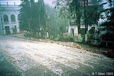
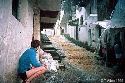
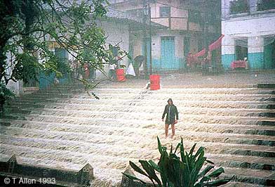
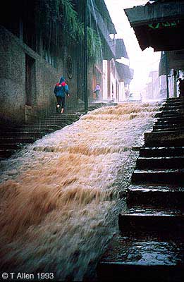
The December 1993 expedition experienced mainly sunny weather, with only a few days of drizzle. A thunder storm again trapped cavers underground this time in Sima Zoquiapan overnight. The April 1994 expedition had the usual mixed weather. Two massive thunder storms occured during the trip flash flooding the caves. One of the storms trapped five cavers at the bottom of San Andreas for 24 hours. The January 1995 expedition experianced more cloudy than the usual drizzly weather, but with little sun. Two seperate days of persistant light-medium rain caused a slow rise in underground water levels. On one occasion this was enough to sump of Cueva de Alpazat. The expedition finished with eight consecutive days of sunshine. The January 1996 expedition had hot sunny weather for most of the duration. There was little cloud and drizzle and no storms. The caving season extends from mid November to mid May. Generally the closer to November you go the more likelyhood of persistent drizzle with occasional heavy rain. The closer to May you go thunderstorms are more likely. In our experience the period between early January and early March would seem to be best. Although nothing is guaranteed even then. None of the articles written in the 1970's mention any flooding events and yet flood risk became such an important factor in our exploration. We can only conclude that weather patterns have changed in recent years. This is backed up by comments made by the local population. The thunderstorms we experienced arrived without warning and proved completely unpredictable. None lasted longer than an hour but turne tracks into rivers within minutes. The steep, cobbled streets of Cuetzalan turned into foaming cascades which were hazardous to cross. The steep slope angles which charecterise the area swiftly channel the waters underground. Flooding in the caves is rapid with water backing up behind the many boulder chokes. The drizzly weather, although unpleasant on the surface, has little effect on
underground water levels. This is probably the safest time to explore the furthest
reaches of the caves. It is interesting to note that however miserable the weather
in Cuetzalan maybe a journey of 20-30km to the south-west will almost certainly find
sunshine. Once the eastern facing slopes with their sub-tropical vegetation are left
behind, the high plains of the Sierra Madre Oriental are reached. These quickly
change to an arid, cactus and scrub landscape with a dry climate. Ideal for drying
caving gear. Observations On The Flood Of 6th April 1994 The morning began sunny. Around mid-day a sudden gust of wind heralded the onset of a massive thunderstorm. The sky turned black and within minutes torrential rain was falling. The streets and tracks around the town were soon turned into rivers. The heavy rain lasted for only three quarters of an hour and drizzle persisted for the rest of the rest of the afternoon. A team of five cavers were at the bottom of the San Andres system when the storm began. At this point in the cave a large inlet enters and the passage is 20m wide by 30m high. The San Andres stream was first to respond approximately one hour after the storm began. The large inlet started to rise soon after and water levels rose 6m in the next two hours. Levels than began to drop much to the relief of the team. The San Andres stream had peaked and was know receding. However, the inlet stream continued to rise and soon water levels were on their way back up again. Water was soon backing up from the boulder choke downstream and rising steadily at 1m every 15 minutes. The water continued to rise to a height of 20m before slowly receding 8 hours after the storm began. By 6am the next morning the cave was just passable and an exit could be made. Many sections of the stramway had sumped off during the height of the flood. Cueva de Alpazat, the flood overflow for much of the area, probably responded about 6 hours after the start of the storm. A vast quantity of water typically gushes out of the normally dry entrance for a few hours. Normally the main stram rises from a sump, crosses the overflow passage half a kilometre into the cave, and disappears into a small outlet in the far wall. When the volume of water becomes to great and the outlet can't take any more the whole passage sumps up to a high point and water then flows out of the entrance. As the flood abates a sump remains, flooding 300m of the entrance series below the high point. The sump gradually receeds over 6 days (timed on three occasions and with no further rainfall) until the outlet can again cope with the volume of water. |
||||
| Expedition Weather Reports | ||||
| << Climate | Main Index | Geology >> | ||