The following article was originally published in
Caves and Caving, No.62, Winter 1993.
 |
Caving in Cuetzalan - Mexico
Tim AllenTim Allen describes the results of two expeditions
to this promising area. Over 10km of new passage has been discovered.
Much work has also been carried out methodically resurveying and documenting the previous
work of other groups. All photo's by Tim Allen. |
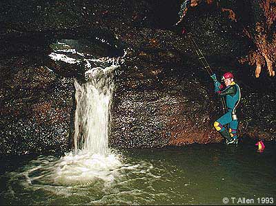
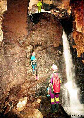
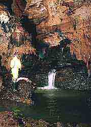
| 6m pitch in Resistol.
The water is at least 3 times this volume at the current limit. |
Cuetzalan is a small Mexican town situated in the north of the state of
Puebla. It is situated on a limestone hillside beneath which lie many
kilometres of cave. Collectively known as the Cuetzalan system it was
described in the late seventies as 'One of the finest and most going cave systems in the
world'.
Between 1976 and 1980 the three streamways of Chichicaseapan,
Atischalla and Resistol were connected together and surveyed to nearly 20km in length.
Three other caves: Atepolihuit de San Miguel - 6km; Zoquiapan - 4km and
San Andres - 4km, running parallel to the main cave, together with many other minor caves
were also explored .
In the early 1980's the area was abandoned despite the many leads that
remained. This was probably due to the survey information being fragmented amongst
the different groups who had explored the caves. No survey was ever published and it
would have been difficult to know who had done what and where.
In 1988 members of the Northern Cave Club visited the area with Mexican
caver Ramon Espinasa. Having confirmed the areas potential efforts were made over
the following three years to obtain the survey data, to no avail. All that could be
found were various articles either on specific trips or of a very general nature.
The only survey was an A4 line drawing of some 30km of cave passage!
Not enough to be of much use and the decision was therefore taken to start again from
scratch.
To date two small expeditions have been fielded. The first over
Christmas 1991 and the second over Easter 1993. A total of 44km of cave passage has
been surveyed, a quarter of which is made up of new discoveries. There follows a
brief summary of the main caves explored to date.
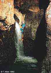
Cascade pitch and swim, Resistol. Note the water
cutting into the conglomerate base rock.
|
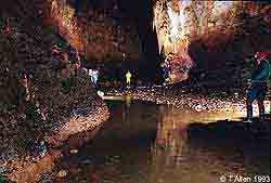
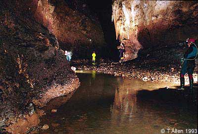
Approaching Bobs Folly in Resistol. Notice the contact
between the conglomerate and limestone, a common sight in Cuetzalan caves.
|
The Cuetzalan System
A great deal of effort was put into resurveying this cave during both expeditions.
It is thought that all of the original system has now been rediscovered and
the various connections made. A few odds and sods of new passage have been found.
Exploration is currently centered on the main downstream lead where in 1980 a
Belgian group broke through a 500m long boulder choke to find a further kilometre of often
difficult passage. The cave was still going at this point 'hands and knees in
water'. Progress has been hampered by labyrinthine chokes, sump bypasses and
pounding waterfalls. Current exploration has reached the top of a very wet pitch,
within a few hundred metres of the Belgian limit.
The San Andres System
Very little information was available on this cave except that it ended at a large
choke after about 4km. The cave was pushed on the '93 expedition when the choke was
passed (again 500m long). The large stream passage was regained and followed for
several kilometres with the way on left wide open. A serious flooding incident
occurred here when two members were trapped between an impassable pitch and a sumped-off
section of the main drain. Fortunately a rope had been left on a climb to a roof
passage where they were able to sit the flood out in safety. They were rescued as
water levels receded. At its height the water rose 8m in as many minutes.
Sima Grande
This cave was an entirely new discovery, located to the east of Cuetzalan and San
Andres. It has two entrances, four large inlet passages and two downstream routes.
Explored during the '91 expedition it was left with many leads unchecked.
No time was available in '93 to continue work here.
Sima Chapultepec
Another new discovery in '93, located only a few hundred metres from Cuetzalan town.
Entered via a rift in the side of a blind surface shaft, a series of four
pitches lead to a small streamway. Eventually this emerges into the main passage of
Sima Zoquiapan, a known cave not yet re-explored.
Atepolihuit De San Miguel
The cave was partially resurveyed during a brief visit to the area in November '92.
The cave is one of the main sinks and reportedly ends in a sump after 6km.
Before the sump a large inlet enters which may be the water from the
Cuetzalan system. A fossil passage offers a possible continuation downstream
but ends in a boulder choke.
The Resurgence
The location of the resurgence had remained a mystery until the discovery in '91 of a
large volume of water bubbling up in a river bed. If this is the main water it gives
the system a depth potential of just under a kilometre with a direct sink to resurgence
distance of ten kilometres. Unfortunately the site is completely submerged. On
practically the last day of the '93 trip an open cave was located, at a similar elevation,
in a valley parallel to the active resurgence. In the time available it was explored
for about a kilometre following a howling draught with no end in sight. Needless to
say a return is planned.
The Future
The geology of the area shows that all the caves are formed on the contact between the
conglomerate base rock and the limestone. the dip averages eight degrees and
although small fractures have influenced cave development the trend remains to the north,
down the dip. As can be seen from the map the potential remains for a huge cave
system. All the downstream leads in the major caves are open as is the cave in the
resurgence area. It is only a question of filling in the blanks!
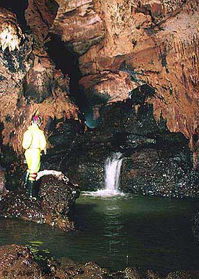
Resistol: formations of all kinds are common throughout the
cave.
|
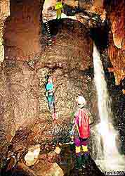
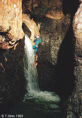
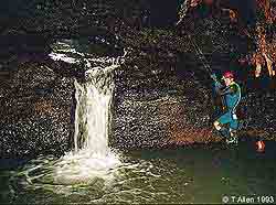
The 8m waterfall pitch in Resistol |
Tim Allen Relates a 12 hour traverse from Resistol to
Chichicasapan
The flavour of the caving might best be conveyed by describing a single memorable trip
into the Cuetzalan system. On the 22nd March 1993 Mick Nunwick, Nick Jones and
myself entered the system with the intention of continuing the survey downstream. 12
hours later we emerged from a different entrance having traversed some eight kilometres of
passage without retracing a single step.
On that day I rolled out of my bed and into the ensuite shower. I
narrowly missed being caught in the nuddy by the sweet, young landlady's daughter who
burst into the room to change the sheets. Out on the communal balcony the team were
busy sorting out kit for the days adventures. Mick had already changed my carbide.
He's so keen he'd probably been ready for hours and this was his way of
telling me to hurry up. We wandered down to the market for the rather unusual caving
breakfast of banana milkshake. For the miserly sum of 10p you get two raw eggs, two
bananas, a load of milk and sugar all whisked up into a very filling meal. If you've
got any room left there's always tacos, tomales, toyoloyos, etc, etc. As you can see
caving in Cuetzalan is no great hardship, on the surface anyway.
We found the entrance to Resistol, hidden by vegetation, in the middle
of a maize field, 45 minutes walk from town. Nick descended the 30m entrance pitch
first to replace a sling rebelay which had broken as he prussiked up on the last trip a
few days before, ou-er! The pitch breaks into the side of a passage. Upstream
leads to a long complex choke which connects to the Atischalla inlets, the top sinks to
the system.
We headed downstream zigzagging along in a walking sized rift while a
wide bedding at floor level offered a more direct route but required stooping and
crawling. Gradually the rift disappears and the passage becomes larger. The
stream runs on a black conglomerate base rock whilst the walls and roof are of limestone
and everything is clean washed. Soon we met several short cascades, some requiring
handlines as they tumbled into deep pools and swimming was unavoidable. The stream
started cutting a channel into the conglomerate before pouring down a 5m pitch. This
was rigged on ladder and landed in deep water where we had to swim a short distance under
the waterfall to get to the bank. Shortly after we reached another pitch of 8m.
This heralds another increase in passage size to 10m wide by 20m high.
We stomped along in the stream for nearly a kilometre, the only obstacles being a swim and
a few climbs. We arrived at a confluence where another large stream enters.
This is the Cohuatichan inlet which leads to several kilometres of active and fossil
galleries.
The combined waters flow down a 5m pitch which was the limit of
exploration last year. Then in higher water conditions Bob North had descended the
pitch to be nearly swept down what he thought was a second pitch. This year,
however, Bob's second pitch turned out to be a mere 30cm cascade. We descended what
is now known as Bob's Folly passing a few more swims before arriving in a chamber with two
ways on. The lower route taken on a previous trip involved a long swim in an awkward
canyon. A higher fossil route offered a possible dry bypass and I ferreted about in
it looking for the way through. Mick and Nick meanwhile got impatient and decided to go
for the known wet route and I eventually followed them.
We had long since abandoned using wet suits in the caves as they were
just too hot. We now favoured wearing thin thermals and carrying an oversuit just in
case we got into a boulder choke or similar destructive passage. Most swims were
short and we only ever got cold when immersed for a long time. Carrying our
oversuits had the great advantage of drying out our thermals on our bodies very
quickly.
The end of the canyon was also the previous limit of surveying at the
top of a flowstone slope. We rigged the climb and set off surveying with Nick on the
tape, Mick on the instruments and me with a book. Within a short distance we were in
a massive chamber, 70m wide with the roof supported by a rock column in the middle, which
seemed to be only an enlargement of the passage we were in.
From here on we always had a choice of routes either up in a massive
bouldery passage or down in the stream channel cut deep into the conglomerate normally
under the right-hand wall. Route finding in such large passage is hard, sometimes
the stream channel became blocked and forced us up to the fossil passage above.
Sometimes the upper route was complicated by jumbles of house sized blocks
and we were forced down into the stream. However many times you traversed this
passage, we thought, you would never do it the same way twice.
We rested at another enlargement, 60m wide, on top of a sand covered
boulder pile. We were perhaps 25m above the stream and 25m below the roof.
Mick was soon goading us into action again and we carried on surveying.
As I had the book I was given the job of finding a route. We tried to stay
high up, traversing along on ledges on the tops of boulders. Sometimes we had to
backtrack to get down drops off the ends of boulders. We were forced back to the
stream when the upper passage just disappeared until we cut back into it, 100m further,
where the water cut across the entire cleanwashed floor and plunged 20m down a rift on the
far side.
A boulder pile stretched upward above it and we nearly packed in for
the day her but Nick climbed the slope so we thought we should survey up to him at least.
At the top it levelled out probably 40m to the stream and 20m up to the roof.
Mick pointed out a roof passage in the far wall and I wandered over to it.
There was a rope hanging down from it. We all knew what it was - the
Boshsteigel Connection.
This was the route that connected Resistol with the streamway of
Chichicaseapan. It had been explored by the Americans but we had failed to find it
from the Chichi side last year and here it was. We celebrated with a bag of
pineapple chunks and added up the days survey, 1.75km.
As we sat eating I had the idea that perhaps we could exit via Chichi
and so complete the first through trip. However, this idea was fraught with
problems. The rope on the pitch was nearly 15 years old with uncertain belays and
Chichi had two other pitches between us and the entrance, one of which was 25m. Our
SRT kits were, of course, back at the bottom of the entrance pitch to Resistol.
However, there was a long bypass to the 25m pitch but that too had a short
pitch in it. Mick reckoned he could probably freeclimb that and the other 10m pitch
so that just left this one to be overcome. It was about 15m high and against a
vertical smooth wall. Mick declined the invitation to climb it hand over hand so it
looked like we would be retracing our steps.
I was now all psyched up for the trip and refused to be beaten. I
rummaged through the tackle bags; three ladders, bolt kit, wires, tape... That would
do. I made an improvised harness and prussik slings out of the half inch tape and
set off. I told myself that rope stored in these conditions would be fine and
knowing the Americans it would be attached to some huge natural belay.
The rope was a bit muddy near the top and the slings slipped a few
times but other than that it worked like a dream. Then as I pulled over the edge I
saw the belay. Gulp! The rope was tied with two half hitches to a long tape
which in turn was attached to a lump of rust that had, no doubt, once been a perfectly
good home-made hanger. I didn't dwell on what might have been and arranged the
ladders for the others, to a different belay of course.
We were in unknown territory but the draught pointed the way and within
a few hundred metres we emerged into a huge chamber 100m across. Although none of us
had been here before we knew this was part of the old fossil route which ran between the
two streamways. A brief search along the opposite wall revealed the draught again
and we dropped steeply down into the Chichi stream. We splashed happily up the broad
passage to a deep canal. Swimming is much more unpleasant in Chichi as the stream picks up
a fair amount of crap from the town above and the air has a slight Domestos taste to it.
However we soon reached the base of the 25m pitch where the full stream pours
down into the middle of a chamber.
We ignored the rope and climbed up the boulder slope to the right into
a much older route. None of us had been in this passage before and only Mick had
seen the pitch at the far end, and then only from the top. Continually climbing up
breakdown we sweated our way up nearly dying of heat exhaustion. The passage ends at
a beautiful wall of sparkling flowstone and if we couldn't climb it we had a bloody long
way to return to get out. Mick made it look easy and lowered a ladder down for Nick
and I. We had cracked it as we knew we could get up the next pitch, with the slings
if necessary.
A wide bedding brought us out into the streamway again and a very
pretty passage with pools on the floor and a roof covered in straws, eventually led us to
the base of the 10m pitch. Mick had got this licked by the time Nick and I caught up
although if it hadn't been rigged with a rope it would have been impossible. Above
the pitch the character of the passage changes.
The dip is steeper here and the stream has cut a deep narrow trench
into the conglomerate. We found it easiest to traverse the passage high up at the
contact between the conglomerate and the limestone. Here there are ledges that avoid the
many awkward cascades and pools sometimes up to 10m below.
The steepness of the passage and the strenuous traverses had us puffing
a bit but we were nearly there. An inlet enters on the right and we took this turn
which leads to the closest of Chichis two entrances. Within minutes we were climbing
up the boulder slope and fighting our way through the thick vegetation of the entrance
doline.
We had done it, totally unplanned, the first traverse of the system.
We were knackered but well chuffed. We walked through the maize fields
the short distance back to town. It was midnight. Back at base the rest of the
team were well pissed up, and we joined in the fray with lots of back slapping and tales
to be told. I don't remember much after that!
| The Caves Of Cuetzalan - Total
Lengths Surveyed To Date (1993) |
| Name |
Year |
Length(m) |
VR(m) |
Notes |
Cuetzalan
System
San Andres
Sima Grande
Tasalopan
San Miguel
Sima Chapultepec
Cruz Verde
La Providencia
Zoquita
Sima Talcomitl
Sin Nombre
Grotbag
Bat In The Face
Cueva TalcomitlTotal
Length |
91/93
93
91
93
92
93
91/93
93
91/93
91
91
93
93
91 |
21,218.8
8,248.8
2,834.8
2,736.3
2,399.5
2,254.8
1,1465.3
874.6
623.3
618.1
415.7
355.1
125.0
71.6
44,241.7 |
495.6
409.0
135.0
85.0
159.8
269.5
71.0
36.7
38.0
74.6
64.9
24.6
69.4
11.8
|
Main downstream lead continues.
Main downstream lead continues.
Many leads remaining - may connect to Zoquita.
Exploration complete.
Main downstream lead continues + highlevels.
Enters main cave of Zoquiapan as an inlet.
Exploration complete - no connection to CS.
Exploration complete.
Ends in a sump.
Continues - narrow.
Exploration complete.
Exploration complete.
Exploration complete.
Exploration complete. |
Back To Top |